
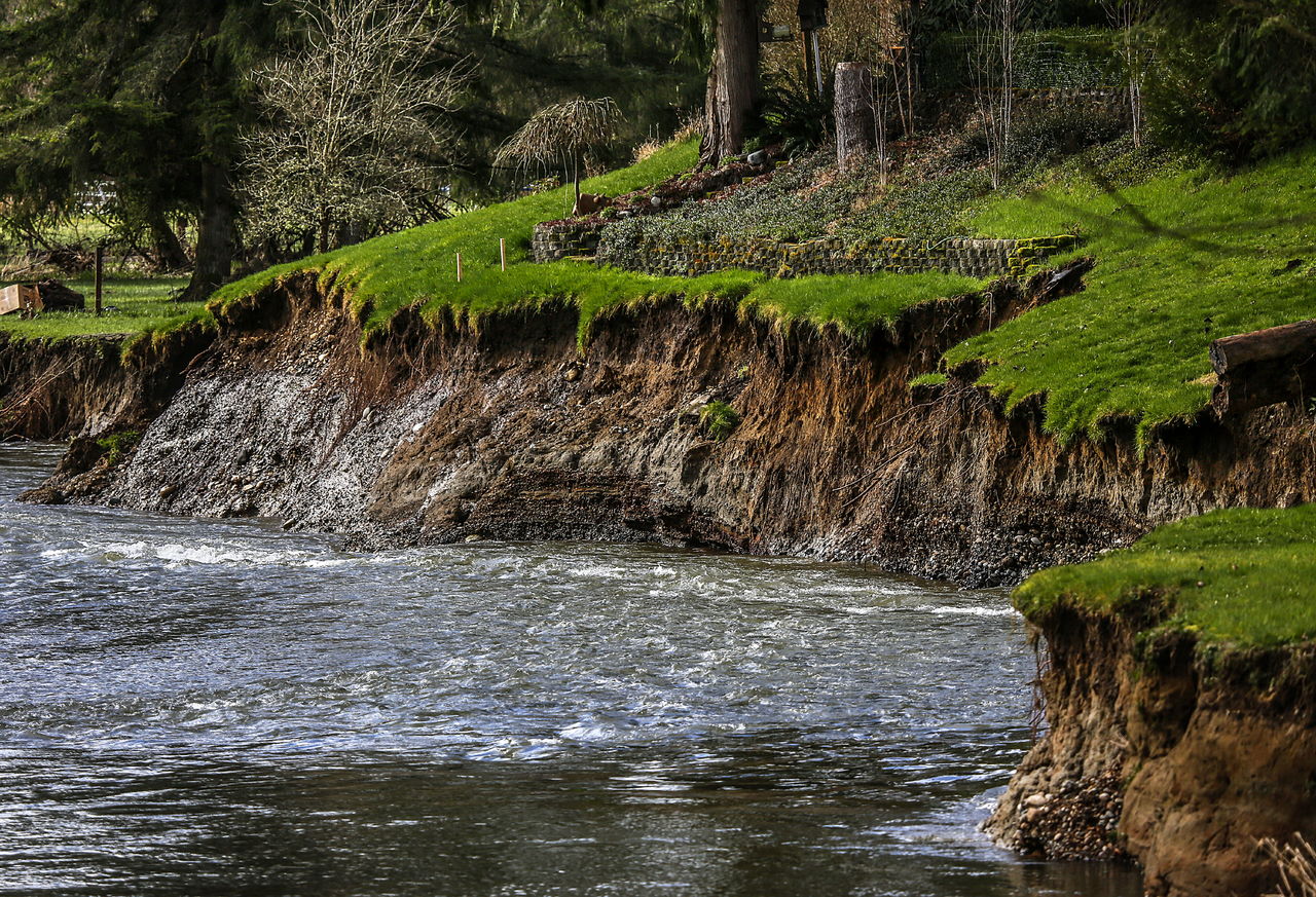
LOCHSLOY — The Pilchuck River has carved off chunks of the neat, green back yards in the Lochaven neighborhood off Highway 92.
A chainlink fence between two properties drops off at a sheer bank and the metal disappears into the water. A lip of grass hangs off the edge of the yards, where the ground has given way to the meandering river.
Homeowners are forming a flood control district to pay for work to stabilize the bank. The district would let them apply for grants, issue bonds and tax themselves to pay for projects.
“The only other way to protect private properties is to go it alone and then you get a patchwork of flood control projects,” said Mark Thompson, president of the Lochaven Riverfront Homeowners Group.
He and his neighbors have kept track of their disappearing yards. As of Feb. 25, they’d measured up to 165 feet lost since 2012 in the worst areas.
People in the proposed Lochsloy Pilchuck Flood Control District petitioned the county and paid $5,000 to cover expenses for studying the district. A total of 16 properties are involved and 14 have homes on them. Projects for the district could include putting woody debris in the water to disrupt the current and hardy plants on the bank to hold it together, Thompson said.
An engineer’s report should be presented to the Snohomish County Council later this month or in early April, said Tom Rowe, a division manager in the county’s planning department. If the council decides the district is feasible, there would be a public hearing, an election for affected property owners and a council vote. It could be finalized as soon as the end of April.
The homeowners worry that’s not soon enough. They applied to the county for emergency permission to put rocks and rip rap along the bank and to build three groins that would jut into the river to divert the current near the fastest eroding spots.
Snohomish County approved the request Monday. Engineers found that five homes are threatened by the river and eight others could be in danger as erosion continues.
The request also needs to go through the Army Corps of Engineers and the state Department of Fish and Wildlife.
It hasn’t been submitted to the state yet, but it seems likely that officials would deny it. The situation doesn’t qualify as an emergency under the Department of Fish and Wildlife’s regulations, habitat biologist Jamie Bails said.
“Our definition is that (an emergency) means an immediate threat to life, property or environmental degradation,” Bails said. “There would have to be a bridge falling in or a house falling in to qualify for an emergency. When they request it, we’ll give them that same answer.”
Putting rocks along a bank is not the best way to deal with erosion because it “locks the bank” and creates more erosion elsewhere, she said. Other options include putting in woody debris or rock barbs. Groins like the ones proposed in the homeowners’ request are a possibility, but they should be part of a detailed plan, not an emergency reaction, Bails said.
“We’ve been having ongoing discussions with these landowners for two or three years about what can be done out there,” she said. “This is not new.”
Neighbors describe their current situation as critical. The river rises rapidly during floods. It’s not just houses that are in harm’s way, it’s the families inside, homeowner Dawn-April Roberts said.
The river eats at the bank even when it’s not flooding. A retaining wall behind one house has started to fall in. If the state denies the emergency request, it would prevent people from living safely in their homes, Roberts said.
County officials hope to work with the state on getting approval for the homeowners, Rowe said.
“Typically, when the county issues an emergency permission, other agencies follow suit,” he said.
The county can issue permits after work starts but the state requires them beforehand, Bails said. If homeowners work on the bank without a permit, they would be violating regulations and could be ordered to stop. She’d rather plan a long-term solution.
The flood control district would be focused on longterm bank stabilization, Roberts said, but homeowners need help now.
They’re raising money so they can start work immediately if they get permission. A GoFundMe account is set up at tinyurl.com/PilchuckErosion and the group is looking for people willing to lend their expertise or equipment. Any money that isn’t used for the Lochaven project would be set aside to help other property owners facing dangerous erosion, Roberts said.
More land is being lost elsewhere along the Pilchuck.
Less than a mile away, another bend in the river is encroaching on Highway 92. An orange safety fence marks a spot where the riverbank is barely 50 feet from the highway. White and gray pipes stick out from the side of the bank near what’s left of a gravel drive. The river claimed a house in 2012. An overgrown shed on a nearby property is about to topple, as well.
The state Department of Transportation plans to start a $3.4 million project this summer to stabilize the bank. Planning started in 2013, not long after the house fell in. Work must take place during the summer and early fall, when the river is low.
“Contractors are going to go in and use logs, rocks, plants and root wads to stabilize the slope up to a certain flood point so when it does flood again the bank will be protected,” WSDOT spokeswoman Lisa Van Cise said.
No work should be necessary on the highway itself, though the road might be narrowed to one lane at times while crews work on the bank. Roughly 11,000 cars and trucks use that stretch of Highway 92 each day.
Snohomish County also has a project slated to start soon. Crews plan to begin work in April to replace a one-lane wooden bridge that crosses the river on 64th Street NE, in the Lochaven neighborhood.
From that bridge, there’s a clear view of the steep, muddy brown banks where yards abruptly end and the river keeps eating its way toward the houses above.
Kari Bray: 425-339-3439; kbray@heraldnet.com.
Talk to us
> Give us your news tips.
> Send us a letter to the editor.
> More Herald contact information.
